Wednesday, 4 December 2013

What’s in a photograph?

By Lucy Clarke (@DrLucyClarke)

Everyone is familiar with photography, with the rise of digital cameras and increasingly high resolution cameras available on mobile phones and tablets people are photographing everything from their holidays, pets, family, friends and even themselves. I love photography and enjoy capturing images of my travels, but I also use photographs in a very different way as part of my research: rather than just appreciating their aesthetic value I use photographs to recreate and measure features on the Earth’s surface and in the lab.

In remote areas where it is difficult to access a location or when looking into the past, photographs can often be the only option available to explore an area. Historic photographs are therefore extremely valuable, as they provide a record of what something looked like at various points in time and so can be used to look at temporal change. This is especially useful if an extreme event occurs in a location that has never been measured before, so you can look at the impact the event had. An example of this is shown below; the 2 photographs show the Poerua alluvial fan in New Zealand before and after a big event. In 1999 a large rock avalanche occurred in the headwaters of this system forming a dam in the gorge below, the water ponded up behind this for 2 days before it finally burst, creating a flood wave that engulfed the area downstream and caused the river to avulse (move to a new location) and deposit large areas of gravel on top of the agricultural land. Using photographs from before and after this event enables identification of the area of land that has been affected and the new position of the river channel to try and assess the damage.


Aerial photographs from 1984 (before) and 2005 (after) the 1999 flood event on the Poerua alluvial fan in New Zealand (Images courtesy of NZ Aerial Mapping Ltd and GeoSmart)

Although it is useful to look at these photographs and see the changes between when they were taken and what is there now, it doesn’t help us to actually measure anything or quantify the change. So in my research I use a technique called photogrammetry, which allows me to process photographs and extract quantitative data from them. In its simplest form, photography converts the 3D real world into a 2D image, and photogrammetry converts this 2D image back into a 3D representation - using information on the type of camera and lens used to take the image and the relationship between the camera and the ground at the time that the image was captured. This requires two overlapping images of the same place which are viewed at the same time in a single 3D image, in what is known as a stereo-image. Traditionally, this was done using a stereoscope (which uses mirrors and viewing lens to fuse the 2 images together when you look at them - like a magic eye picture) but in modern digital photogrammetry this is done using specialist software on a computer using a 3D screen and glasses – like when you watch a 3D film at the cinema. In the digital workflow the images are adjusted according to the camera parameters and georeferenced using the coordinates of known positions from the ground to create a true scale representation. A digital elevation model (a 3D map of the surface area) can then be extracted and used to measure features, this gives the same results as it would have done if you were standing on the ground measuring it.
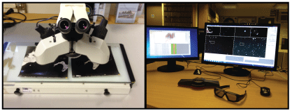


Ways of viewing images in stereo (a) the traditional method using stereoscope and (b) my digital photogrammetric computer set up with 3D screen and glasses

Photogrammetry is most commonly used with aerial photography but it can be applied to any overlapping imagery if you have the correct information. For example, below is a photograph and associated digital elevation model I created from my alluvial fan experiments, outlined in my previous blog post: What drives change on alluvial fans? 


Photogrammetry software is expensive to purchase and processing the images can be complex and involves training, so traditionally photogrammetry has only been used by specialists. But recently there has been a development in something called Structure for Motion – this involves taking multiple photographs of objects from different angles and then uploading these into software that uses photogrammetric principles to automatically create a 3D model. This software is available on the web – e.g. Bundler (free to download), Photosynth (free to download) and AgriSoftPhotoscan  (the demo version is free, which allows you to create models but not save) - so you can upload your own photos and have a go at creating your own 3D model from them!


An example of the 3D model created by Structure for Motion (Source: Goesele et al, 2007)


I first used photogrammetry many years ago for my Masters’ thesis and since then I have incorporated it into all of my subsequent research, whether it is analysing a field site or an experimental landform. In my first blog post I mentioned that I am a fluvial geomorphologist (my research is all about rivers), but since writing that post I have changed jobs and I am now using my photogrammetry skills in a whole new environment – Antarctica – working for the British Antarctic Survey in Cambridge. I have just started a new project using an archive of approximately 30,000 aerial photographs of the Antarctic Peninsula that date back to the 1940s to investigate how glaciers in this region have changed in the last 70-80 years, an area little is currently known about. This means that I am lucky enough to have access to the most amazing photography of the one of the most remote and stunning places on the planet and will be working with this for the next couple of years, which I will keep you updated on in future blog posts.

(a) Part of the archive of aerial photos held at the British Antarctic Survey, examples of historic aerial photos of the Antarctic Peninsula from (b) 1950s and (c) 1980s


Reference:
Goesele M., Snavely N., Curless B., Hoppe H. And Seitz S. 2007. Multi-View Stereo for Community Photo Collections. Proceedings of ICCV: Rio de Janerio, Brazil: 14-20 October 2007.


Wednesday, 27 November 2013

The Challenges of Researching with Children

by Elsbeth Robson


I’m a social geographer who researches mostly in Africa. I’ve been doing research with children since I undertook my PhD fieldwork in a village in Northern Nigeria in the early 1990s. 

Child traders and headloaders in a periodic rural market in Hausaland, Northern Nigeria c1993.

That involved spending a lot of time in the village and the markets nearby observing what children were doing in public space and the important work they do running errands and as traders. Hausa children are well known for selling cooked food for adult married women observing Muslim seclusion (purdah). We also asked them to tell us all their activities the previous day to collect 24hour recall data to look at children's time use (Robson 2004).


After getting my PhD, once I was a lecturer at Keele University I was able to do some work in Zimbabwe - thanks to a British Council link with the University of Zimbabwe). I turned to look at the work of young caregivers – children with responsibilities caring for a sick or elderly adult at home. Interviews with caregiving children and also interviews with adult key informants (in the health service, NGOs supporting children, hospices and the like) were the main data collection approaches (Robson et al 2006).


A decade later in Malawi I was part of teams undertaking three ESRC-DFID funded projects on (i) children, transport and mobility (available here); (ii) impacts of AIDS on food security for youth (available here) and (iii) youth and mobile phones. Each of these research projects involved researching directly with children and young people using a range of qualitative, quantitative and/or participatory methods.

Secondary school pupil receiving certificate and souvenir photograph after training workshop for young researchers – were ‘educational benefits’ enough justification for her to miss several days of schoolwork which she’d have to catch up in her own time?

All these projects threw up different ethical challenges for researching with children and young people not just in Malawi, but also in Lesotho, Ghana and South Africa where research was conducted as part of the multi-country studies. 

Young researchers in their school uniforms hard at work collating results of their research on transport and mobility with other young people in their high density low income urban community within the city of Blantyre in Southern Malawi – should they be paid for their work?

Local youth band preparing to play at end-of-project community village meeting – was providing feedback on research findings, entertainment & refreshments (purchased from village small businesspeople) giving back enough?

We had to ask ourselves some hard questions, like:

  • Was it justifiable to interview recently bereaved children who cried when questioned?
  • Where interviews were incomplete because a child was too emotionally upset to continue, should we re-visit in order to try and complete the interview?
  • Should young people miss school in order to take part in training to be young researchers?
  • Is it contravening child labour legislation to employ children to undertake peer research with other young people?
  • If we paid young people to work as researchers should it be in cash or kind? How much?
  • How should families and young people in poor communities who take part in participatory research be recompensed for their time? Grocery packs? Refreshments? Copies of the data? Photos of themselves? A party?

These are all real ethical encounters I have faced in working with young people in research in various sub-Saharan African countries. Encountering ethical dilemmas in fieldwork with children can be difficult for researchers wherever in the world they work. Unexpected situations and challenges arise however much we think we are prepared and willing to ‘do the right thing’. All aspects of research raises ethical questions - even writing this blog raised ethical questions about whether to include photos of people without their permission and whether to use their names, or identify specific places, on the captions.


Now there is a new online resource to help researchers www.childethics.com . As part of the Ethical Research Involving children (ERIC) project we came together with nearly 400 members of the international research and NGO communities including UNICEF to contribute case studies and publications from our own research experiences to guide others towards ethical research involving children. The ERIC website www.childethics.com is intended to be an online space to share stories, experiences and learning about ethical issues and concerns that shape research involving children and young people around the world. Take a look and let us know what you think.


Wednesday, 20 November 2013

Overcoming Anglocentrism? Researching overseas

By Kirstie O'Neill (@KirstieJONeill)


What do we do as researchers?  I’m a post-doctoral research associate in the University of Hull’s Department of Geography, Environment and Earth Sciences and I’m a social scientist.  This generally involves speaking to people as part of ‘doing’ research, although there are lots of research methods in social sciences which don’t involve directly speaking to people.  Here I’m writing about my experiences of ‘doing’ research outside of the UK, from a current project in Germany and some of my PhD research in Italy.  In particular, I’m thinking about how social scientists speak to people in other countries when they aren’t necessarily fluent in those languages.  

I never thought my A-level German would be of much use beyond school, but almost 18 years later I found myself refreshing my memory so that I could go to Germany to do a research project.  Part of that preparation involved a mountain biking holiday with my husband to the Black Forest where I found that I could remember more than ‘hello’ and could even hold a basic conversation, much to my surprise.


On returning from this, I swotted up so that I felt a bit more comfortable about living in Germany for almost a month to conduct interviews with green building businesses and policy makers in Germany, from Freiburg-im-Breisgau to Berlin, and Dresden to Cologne.  


Admittedly, many Germans speak impeccable English but I still had cause to use my German in navigating everyday life in Germany (in particular, buying cakes!).

My grant for this work in Germany (from the British Academy) included a small budget for translation in the field, but as has been written elsewhere, doing research through someone else’s ‘voice’ comes with its own issues.  In particular, social science research which involves in-depth and detailed conversations in other languages can potentially cause problems, from causing offence to asking the wrong questions or not getting the ‘right’ data.  Working with interpreters who are specialists in languages but who are not necessarily familiar with your area of work and related technical or specific terminology (in my case relating to green building in Germany and local food in Italy, see below) can be quite challenging, and trying to make sure you find out what you need to but being reliant on someone else’s interpretation of what you actually mean can be interesting!  In Italy in particular, the translator would have quite long bursts of conversation with the interviewees and then only feedback a sentence or two to me, like a Monty Python sketch – interviews can be such dynamic interactions that if you’re not following it all you risk missing vital opportunities to ask questions. 

Community apple festival, Abruzzo
As well as visiting Germany for research earlier this year, my PhD research involved fieldwork in a remote part of Italy, the Abruzzo region – stunningly beautiful but with very few English speaking people around.  I was lucky to have funding to take lessons in Italian and I love learning the language (I try to continue this post-PhD), but there is a difference between taking classes in the UK and trying to have detailed and specific conversations with specialists in their field.  Italy was quite different to Germany as only one interviewee wanted to speak in English – transcribing interviews in Italian and then translating to English was tough, but did really advance my language skills and vocabulary of Italian words.  In hindsight the extra few months I was allocated for this aspect of my PhD research wasn’t really enough since I started from scratch learning Italian! 


Certificate for local food producers
in the Majella National Park, Abruzzo
 This part of my PhD research was the bit which most worried me, and right from starting the PhD I was concerned about how I would set this up, whether people would respond to requests for interviews and whether I would be able to speak to them and understand them (quite apart from a month away from home without internet access and with patchy mobile phone coverage for a UK mobile).  It took quite a bit of setting up and a very early flight from Manchester airport, but the people I interviewed were incredible, and welcomed me openly – they were very interested in my research and were happy to tell me their experiences of local food systems in their part of Italy.  My PhD research was looking at local food systems and the contribution they can potentially make to rural development – quite different issues came up in Italy compared to my UK study area of East Yorkshire.  The photos below illustrate some of the differences in landscape and therefore the potential for different types of farming and food production. 


Bales in Yorkshire Wolds, East Yorkshire
View from agriturismo, Abruzzo
Oilseed rape field, East Yorkshire

Campo Imperatore, Abruzzo


How and why did I choose to visit these particular places?  With my PhD research in Italy it had already been decided that the Abruzzo region would be the case study region, based on a long standing relationship between the University of Hull and a group of local food producers running a cooperative called Parco Produce (Produce from the (National) Park).  The area also has a LEADER rural development programme (funded by the EU) like my case study region of East Yorkshire in the UK.  For Germany, this idea came out of research interviews with green building businesses in the UK who repeatedly stated how advanced Germany is in many areas of green building (interestingly, many Germans stated how advanced the UK is in terms of straw bale building!).  Germany is a pretty big country, so I started to research on the internet which areas would be good to visit - Freiburg was fairly obvious as it promotes itself as a leader in green building, but I also found interesting clusters around Cologne and the Rhineland more generally.  I also visited some of the national organisations based in Berlin and Stuttgart.  There was plenty more I could've done in Germany but I only had funding for three weeks in Germany which limited my possibilities...another time perhaps!

I was surprised when I went to Italy 4 years ago how different it was to where I was used to living – I stayed around the Sulmona area (think The American with George Clooney), which is mountainous with dispersed rural populations.  I was definitely recognisable as ‘not local’ but everyone was really friendly, and wanted to know where I was from and what I was doing.  Germany was a different experience as I mostly stayed in towns and cities which were, on the whole, more impersonal and apart from meeting up with interviewees and colleagues from German Universities I didn’t really get to meet ‘local’ German people.  I travelled to and from Germany without flying (bus, boat, train, tram etc.) and this was where I met more people.  ‘Doing’ research outside the UK is a great opportunity to complement knowledges and experiences of the places we’re used to with those we’re not used to – it’s definitely not a jolly but can be really good fun!  I’ve previously written a blog post about the German research (http://gees-talk.blogspot.com/2013/08/building-green-homes-what-does-this-mean.html) and there’s one in the pipeline on my PhD research too...