Showing posts with label geology. Show all posts

Wednesday, 5 June 2019

Making waves and moving sediment

Dr Hannah Williams has been a Post-Doctoral Researcher in Physical Geography at the University of Hull since April 2017. Hannah is part of the Hydralab+ project, a large European project that brings together researchers to improve experimental hydraulic research to better address climate change adaptation issues. Here she talks about a recent set of experiments carried out at the Total Environment Simulator.

Mixed Sediment Beaches are commonly found at high latitudes around the world, including amongst other locations, along the coastline of the United Kingdom. These types of beaches can consist of a mixture of both sands and gravels, and behave differently under hydrodynamic forcing, such as waves, to those made up of a single sediment size. Although some research, mainly in the 1970s-1980s, has been carried out to gain an understanding of the morphological behaviour of these types of beaches, little is still known about the variations in the morphology of these beaches due to mixed sediment, and how they respond to the hydrodynamic conditions.  The aim of this study was to try and gain some insights into beach response using a physical model.

At the University of Hull, we are lucky that we have a large experimental flume available for research called the Total Environment Simulator (TES). The TES has a working area of 11m by 6m, and is equipped with pumps to allow recirculating flow and sediment, a multi-paddle wave generator for the generation of both regular and irregular waves up to ~0.3m in height (depending on water depth), and finally is equipped with a rainfall generator sprinkler system on the roof. During my time at the University of Hull, I have been involved in experiments using all of these systems, demonstrating just how versatile the flume is. The photo below shows the TES when it first opened in 2000. As a well-used facility, it doesn’t look quite so clean anymore!  


For these particular experiments we were only interested in the beach response under wave loading, so only the wave generator system was required. We constructed a large beach across the opposite end of flume, with a height of 0.8m at the rear, and extending 5m towards the wave paddles. This gave the beach an initial gradient of 1:7.5.To obtain a mixed beach, we chose two different sediment sizes with a large difference in diameter. The fine sediment had a D50=215μm (often known as play sand as it is commonly used in children’s sand pits), whilst the coarser sediment had a D50=1.6mm. To construct this beach, this required over 5 tonnes of each type of sediment (and this including bulking out some of the area deep underneath the beach with breeze blocks), which all had to be lifted into the flume and distributed by hand. The photo below shows the initial smooth beach conditions. 


In terms of measurements, there were two main parameters we were interested in, firstly the incoming wave conditions. To measure these, we had 8 acoustic wave gauges distributed throughout the flume (see below). These recorded information about the wave heights and periods, from which we can gain an understanding of the transformation of the waves as they approach the beach. 


The second parameter we were interested in was the beach morphology. To measure this, we deployed a Terrestrial Laser Scanner. This was mounted from the ceiling above the beach. After each experimental run, the water was drained from the flume, and the 
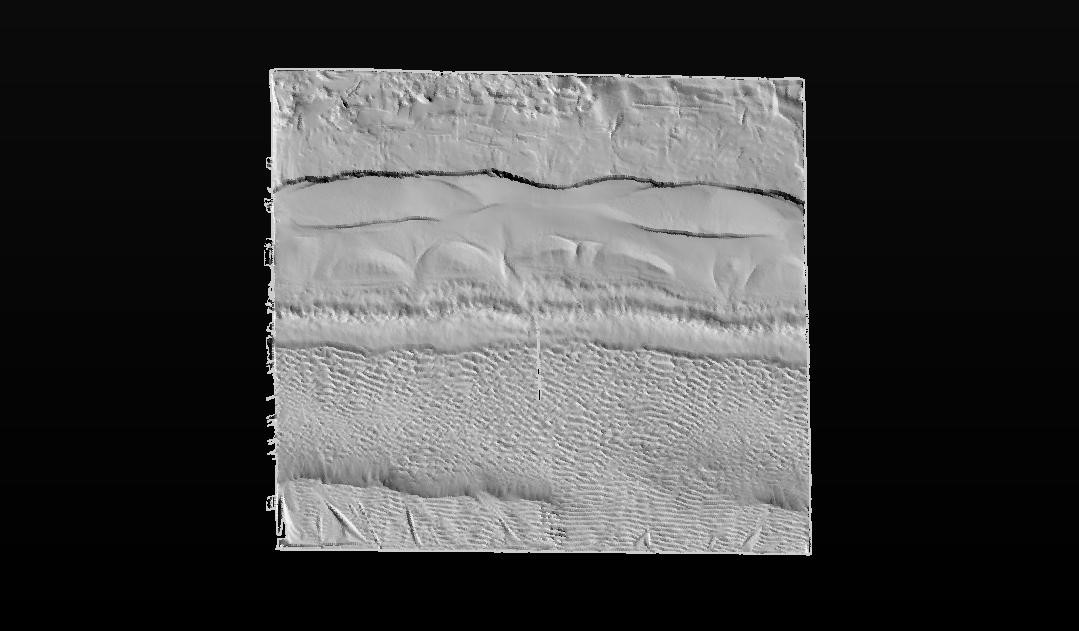
scanner carried out a full 360 degree scan of the beach surface.The image below shows an example of a TLS scan, in which you can clearly identify the top of the swash zone, as well as a berm which has formed part way down the beach, and ripples in the lower section. 


For the actual experiments carried out here, we attempted to replicate some of the influence of the tidal cycle on the response of the beach. The experiments were run at three different water depths, namely 0.3m, 0.4m and 0.5m. In three of the experiments, we hit the beach with an initial storm (H=0.18m, T=2.2s, where H is wave height and T is wave period), at different points in the tidal cycle. One at high tide, then one at mid-tide on the flood tide, and one at mid-tide on the ebb tide. The purpose of this was to try and investigate the effect that timing of the storm with relation to the tidal cycle has on the beach response. After each storm a number of recovery events (H=0.10m, T=1.5s) were carried out, at each depth to complete a tidal cycle. The video below shows some of the experiments in action.


Using the laser scans, we can also examine the differences between scans, giving us an idea of the evolution of the beach throughout the experiments. From these we can obtain information about the amount of erosion and accretion at different points of the beach, and examine if this is different depending on when the storm occurred. The image below shows an example of a Digital Elevation Model of Difference, from which a number of interesting observations can be made.  It should be noted that Red shows accretion of sediment, whilst blue shows erosion of sediment. 


The very top of the beach remains white, this shows that the beach level here remains constant throughout the experiments, due to the wave run-up not reaching this point. Just below this section is a large area of erosion, this is the swash zone, where waves are breaking. This is a very energetic area which results in a large amount of sediment transport, mainly transported further down the beach to the zone showing large accretion. This is known as a berm and often forms as the wave deposits sediment. Below this area, it can be seen that ripples form. This is prior to the wave breaking where sediment movement occurs in an elliptical motion, forming small ripples on the surface. These are all features that are not unique to mixed sediment beaches, however, one feature that is, are the beach cusps. These can be identified in the figure by the regular arc shapes present. There is limited information on the origin of beach cusps, but once they have been created they are a self-sustaining formation. This is because as a wave hits the area of the beach with the cusp, it splits at the point and the water is forced either side. As the wave then breaks, the coarser sediment falls out of suspension and is deposited on these points (known as horns), whilst the water flows into the arc (also known as an embayment) where it in turn erodes out the finer sediment.

These experiments have only just finished, so analysis of the results is still on-going, but hopefully we will have gained some useful insights into the behaviour of mixed sediment beaches which can be used to help devise beach management plans in the future.

For more information on the work of the Hydralab+ project, then please visit: https://hydralab.eu/ 

Wednesday, 11 May 2016

An island apart


by Lindsey Atkinson
Having recently had the good fortune to visit Barbados and some of the Windward Islands in the Lesser Antilles I was struck by the difference between Barbados and the other islands and curious to find out why.  Now you’ll have to excuse me as I am not a geologist so I am wandering into new territory with this blog...

The Windward Islands are the more southerly islands of the Lesser Antilles, including  Martinique, St Lucia, St Vincent and the Grenadines, and Grenada.  They lie near the eastern edge of the Caribbean tectonic plate and are part of the Lesser Antilles volcanic arc.  Being largely volcanic in origin the larger islands are mountainous with a rich volcanic soil and they still have active volcanoes.  Seismic activity in the area is monitored by the University of the West Indies Seismic Research Centre.  
Sulphur springs, La Soufrière, St Lucia


Sulphur springs in La Soufrière, give away St Lucia’s volcanic origins while its namesake, La Soufrière (1234m) on St Vincent, last erupted in 1979 replacing the lake that used to lie in the crater with a lava dome.


Inside the crater, La Soufrière, St Vincent
Barbados stands apart from the other islands being the most easterly of the Caribbean islands, 160km east of St Lucia.  It also differs in being a relatively low lying island, with the highest point at Mount Hillaby (340m), and it differs in origin from its nearest neighbours.

Former coral colonies, Little Bay

Sedimentary layers, Little Bay
Unlike the Windward Islands, Barbados was not formed by volcanic action and it lies at the very edge of the Caribbean tectonic plate.  As the South American plate was subducted under the Caribbean plate sediment was scraped off the South American plate, including deposits of pelagic organisms, forming an accretionary prism.  These layers were subsequently covered by a coral cap.  Both former coral colonies and sedimentary layers  can be seen exposed on the east coast, as here at Little Bay (left).
The movement of the plates resulted in uplifting of these deposits until eventually the island was exposed above sea level.  This happened in stages resulting in ridges which are visible across the island.

Harrison Caves
Little Bay


The island is therefore predominantly limestone, with little surface water as the water filters through the rock.  Beneath the surface are caves such as Harrison Caves with stalactites and stalagmites while on the surface there are dry gullies.  Some of these gullies may have formed when limestone cracked during uplifting or, as in the case of Welchman Hall Gully, where a cave roof has collapsed.  


Erosion has also done its work as the pounding Atlantic waves on the east coast have resulted in the dramatic cliffs of Little Bay and the limestone ‘mushroom’ rocks  of Cattlewash Beach. 
'Mushroom' rock on Cattlewash Beach


And of course erosion of the coral rocks has created the beautiful sandy beaches so beloved of tourists!
Crane Beach, South Coast


Bibliography:
Barbados National Trust   http://barbadosnationaltrust.org 

Donovan SK and Harper DAT (2005) The geology of Barbados: a field guide.
Caribbean Journal of Earth Science 38: 21-33.
Radtke U and Schellmann G (2006) Uplift History along the Clermont Nose Traverse on the West Coast of Barbados during the Last 500,000 Years - Implications for Paleo-Sea Level Reconstructions. Journal of Coastal Research 22: 350-356

Saunders et al. (1984) Stratigraphy of the Late Middle Eocene to Early Oligocene in the Bath Cliff Section, Barbados, West Indies.  Micropaleontology 30: 390-425

The Soufrière Foundation http://www.soufrierefoundation.org/about-soufriere/geology
University of the West Indies Seismic Research Centre http://www.uwiseismic.com/Default.aspx


Wednesday, 5 August 2015

Fracking research: the only way is ethics

By Liam Herringshaw (@fossiliam)

Britain for shale? (Image from Wikimedia Commons, via DECC)

If the contentions of the UK government's energy policy are summed up in a single word, it's probably this one: fracking. According to the August 2015 government survey of public opinions about energy, 28% of UK people are opposed to it, 21% of people support it, and 46% neither oppose nor support it (I'm not sure what the other 5% think!).

Originally a shorthand for the process of hydraulically fracturing low permeability rocks – particularly shales – to extract hydrocarbons from them, the term 'fracking' has evolved and mutated. To some, it is a byword for energy independence and prosperity. To others, it is a swear word of greed and pollution. Fracking is now so variously (mis)used and (mis)understood that it's often hard to know exactly what it encompasses.

If fracking has issues of semantics, then the subject has clearly not been communicated very well. This is a consequence of many factors, but two are particularly pertinent: a lack of fundamental research, and a reluctance of experts to speak out about what is correct or incorrect, and what is known or unknown.

The latter is a consequence of the former. Most people – geologists included – know little about shales, or shale gas, or fracking; only recently have they become a focus of much scientific attention. Even if you are an expert, the need to try and bring sense into the debate is often counter-balanced by the chastening experience of sticking your head above the parapet. Nonetheless, we should try to provide information whenever we can.

Carboniferous shales in the Peak District, UK (Photo by Liam Herringshaw / ReFINE)

Despite all the recent hype about Britain's onshore shale gas potential, for example, we actually know very little about the deep geology of the country's shale basins. Only multi-disciplinary investigations, gathering and interpreting large datasets and then communicating the findings to the public, can help address such uncertainties. But how should research into fracking be funded? And what ethical issues are raised?

If you're implacably opposed to shale gas extraction, you might argue that there should be no funding at all. Since the combustion of fossil fuels is a key driver of climate change, using new techniques to extract and burn them is wrong, and shouldn't happen. That argument has been made to me at meetings I've attended.

Most people, however, recognize the need for peer-reviewed scientific research, even if they are opposed to unconventional hydrocarbon extraction. Fracking is already happening, and will continue to happen. Many impacts – positive and negative – have been claimed on its behalf, but few have been proven with empirical data. To properly inform the debate we need more facts about fracks.

ReFINE - Researching Fracking In Europe

To this end, the main project I have been involved with over the last couple of years is ReFINE (Researching Fracking In Europe). Led by Newcastle and Durham universities, with contributions from many other institutions (including GEES at Hull), ReFINE aims to investigate the key topics of public concern and communicate the findings as widely as possible.
 
As the consortium is part-funded by the hydrocarbon industry, though, there were concerns that the public would see ReFINE as potentially biased. A unique set of ethical procedures were therefore put in place to ensure that funders did not have direct influence over the research outputs. These are:
  • Peer review – all ReFINE papers are submitted to recognized journals for peer review by scholars not involved in the project;
  • Disclosures of interest – all members of the project are required to declare any current or past interests that may compromise their impartiality;
  • Independent Science Board – comprising impartial scientific researchers from across the world, the Independent Science Board (ISB) directs and oversees all ReFINE research, ensuring it is accurate, relevant, and free from industry bias;
  • Offsite archives – correspondence and data relating to the project are recorded using a secure email archive, and made publicly available on request.
No matter how transparent you attempt to be, there will always be those who regard your work with suspicion. Perhaps the best indication of independence is when pro- and anti-fracking groups both perceive your findings as supporting their opponents' position. Having been described as 'frackademics' after publishing one peer-reviewed publication, and then 'nettle wine tasters' after publishing another, members of ReFINE are certainly discovering this.

Ethics are an increasingly important consideration in research projects, particularly those investigating contentious topics. I've not been involved in a project like ReFINE before, with such a detailed ethics policy, but it is surely the right approach. As researchers we need to demonstrate that we are engaging properly with issues of trust and impartiality, especially in relation to funding. As the most recent ReFINE publication has also demonstrated, we must discuss fracking with the public using non-technical language. Only then will people begin to be able to make more informed decisions about the real risks.


ReFINE will be a case study in a future issue of the journal Research Ethics, subject to final approval. To find out more about the project, visit http://refine.org.uk/.

Tuesday, 10 March 2015

WOW Week of Women in GEES: Lynne Frostick


Today, our WOW blog features Lynne Frostick, chartered geologist and Professor of Physical Geography here in GEES at Hull. Lynne first studied at the University of Leicester for a BSc Geology degree, before moving to the University of East Anglia to complete her PhD on “Sediment Studies in the Deben Estuary, Suffolk, England”. This began an esteemed career in Sedimentology which saw Lynne take a Senior Lecturer role at Royal Holloway, University of London and the University of Reading before joining the University of Hull in 1996.


Lynne’s research focuses on two of the major environmental problems faced today: water and waste. Sedimentology has been a core part of this research, particularly sediment and flow dynamics in rivers and estuaries. In this sense, Lynne is perfectly placed at Hull! Lynne also spent a considerable time in Africa investigating the relationship between river development and tectonics. Lynne has always combined field work and modelling, which culminated in the development of the unique Total Environment Simulator – a large physical modelling flume housed in The DEEP aquarium on the banks of the Humber Estuary. This world-class facility is a career highlight for Lynne. “The work I am most proud of is always the most recent. I am very proud of the Deep flume and leading work on ecohydraulics, particularly the Users Guide to Ecohydraulic Modelling and Experimentation”. Over the last few years, Lynne has also used her expertise to address issues surrounding waste, working in research fields as far reaching as biology, chemistry, microchip technology, regulation and policy.

Lynne and Stuart McLelland setting up an experiment at the TES, The Deep (Photo: http://discoverarmfield.com/en)
Lynne’s work has always had strong links with industry and policy. Whilst at Hull, she began a Centre for Waste and Pollution Research at the University which then evolved into the Environmental Technologies Centre for Industrial Collaboration. Lynne’s research is of particular importance to locations such as Hull, as it often strived to understand flooding and coastal management.  She was a leading member of the 2007 independent Hull Flood Review Group and was a member of the North East Regional Environmental Protection Advisory Committee. This has led to Lynne’s recent appointment (16th March 2015 for three years) to the Board of the Environment Agency as lead member for flood and coastal risk management.

This latest appointment is added to a long list of prestigious positions and awards which have honoured Lynne’s achievements. Lynne was the Pro Vice Chancellor for research at Hull (1999-2004), she followed in the footsteps of Darwin to hold the post of the Honorary Secretary to the Geological Society in 1988 (the first woman to hold this role) and then later in 2008 she became the society’s President. Lynne was the 2nd woman to hold this role, and the last to date. At the same time, Lynne became the chair for the British Society for Geomorphology. In 2005, the Royal Geographical Society awarded her with the Cuthbert Peek Award “for advancing the application of physical modelling to environmental problems”. Most recently, in July 2014, Royal Holloway awarded Lynne with an Honorary Doctorate for services and leadership in British Geology.

Lynne’s biggest challenge in her career was “definitely juggling family and career. I had my kids very late- between ages 40 and 44- and having 3 boys under 4 years and a full time academic career was a real challenge! It is a good job I have a supportive husband”. A supportive husband and a good mentor it seems – her advice to (young) GEES women is to “have confidence in yourself and your abilities” but also to get a good mentor. “Mine was Janet Watson and she was terrific”. Lynne is also a leading voice for women in science careers. She is a member of the Government’s Science for Careers Group, was the chair for the Government’s Expert Group for Women in STEM, and has been a trustee of The Daphne Jackson Trust (a scheme to help STEM women who’ve taken a career break to raise a family). In 2009 she was a recipient of UKRC Outstanding Women of Achievement Award for SET Leadership and Inspiration to Others. Now Professor Emerita, Lynne continues to be an active board member and continuing to do research, and can often be found giving talks about why we need women scientists and engineers.


International Women's Day (8 March) is a global day celebrating the economic, political and social achievements of women past, present and future. International Women's Day celebrates women's success, and reminds of inequities still to be redressed. The origins of IWD can be traced to the struggle for women to gain the vote in European countries about a century ago. The first International Women's Day event was run in 1911

Friday, 31 October 2014

Between a rock and a hard place - a lecture on Sci Comm


Review of the George de Boer biennial lecture given by Prof. Iain Stewart, Professor of Geoscience Education, University of Plymouth. 
A guest blog By Dr. Lara S. Blythe

Prof Iain Stewart, geoscientist and TV personality, was the guest of honour at the University of Hull on Wednesday 29th October, invited by the Department of Geography, Environment and Earth Sciences in collaboration with their geology society, the Harker Society, to mark the reinstallation of geology as a degree programme after ca. 25 years of absence. Prof. Stewart presented the George de Boer biennial lecture entitled ‘Between a Rock and a Hard Place’ to an audience of well over one hundred people.

Photo by Rebecca Williams
The title, one might think, is not unfamiliar territory to the professional geologist. However, in this case we should think again. Caught between our science and the public, science communication and more specifically, geoscience communication is something that traditionally we scientists have had a bad reputation for. Good then that the Professor of Geoscience Communication at Plymouth University, whose interests are the cultural and social effects of geology, should give us his take on the matter.

Geology, from the perspective of the public, can be likened to an omnipresent invisible subject, which only becomes visible when necessary: at times of crisis. One issue almost immediately brought to the fore was the L’Aquila case in Italy, where a number of senior scientists and officials were sentenced to six years imprisonment for their 'inability to predict the earthquake' that killed 309 people in 2009 (Hall, 2011; Davies, 2013). This case, akin to several aftershocks, has reverberated through the scientific community and highlights the need for a better relationship between geoscience and the public where good communication is paramount.

Even though being a member of the scientific academic community and being in the public domain may seem like a contradiction in terms, the incentives for academics to communicate are clearly present and, in the face of recent developments (e.g. fracking) are increasingly necessary. For me, academia and science represent a true ecological niche whose inhabitants, as Prof. Stewart explained, approach geological events in almost a complete opposite way to the public in order to understand them. Although this niche is seen as typically attracting introverts obsessed with rocks, in short an ‘odd bunch’, these scientists in fact have a responsibility to interpret their research to the public and inform them about the world.

As Prof. Stewart pointed out, why should the public be interested? and how do we get through to a public that may not even be interested? Combined with poor understanding and many misconceptions, science is not popular amongst the public. Why ever not? I hear you ask; because it contains too much erm, science. Too many details and facts that are in essence, boring.  However according to Stewart, and co-author, Ted Nield (2012) people are interested in other people, a point towards which we need to direct out efforts to communicate effectively. Geoscience is both an applied and a visual science, attributes which enable an interesting and ‘audience grabbing’ story to be told out of an otherwise ‘dull’ subject. Take for example, one of Prof. Stewarts Earth Science broadcasts on the BBC – Journeys to the Centre of the Earth, which links Sedimentary, Metamorphic and Igneous rocks through the building stones used by the Egyptians, Greeks and Romans respectively. This series used a visual art to connect history with geology and its applications, and it proved a hit.

Used to fascinate and spark an interest rather than educate, geoscience communication in ‘quiet’ times facilitates the important transfer of information in times of change and crisis. The public know what geoscience is and know where to find out more information for themselves. As the phoenix of geology and geoscience rises from the ashes left behind at former departments country wide, so (geo)science communication must grow into a new world where academics and the public learn to first respect, then trust, and finally communicate successfully. 

Dr. Lara S Blythe. 

The lecture is available here.

References:
Davies, L. 2013. L’Aquila quake: Italian judge explains why he jailed scientists over disaster. The Guardian, World News, 18 Jan.  
Hall, S. S. 2011. Scientists on trial: At fault? Nature, 477, 264-269.
Stuart, I. S. and Nield, T. 2012. Earth Stories: context and narrative in the communication of popular geoscience. Proceedings of the Geologists’ Association, 124, 699-712.

Wednesday, 10 September 2014

Kinematic indicators in the Green Tuff Ignimbrite: can they tell us about the timing of caldera collapse?

By Dr Rebecca Williams (@volcanologist) & Jodie Dyble

In the summer of 2014 I have had a Nuffield Foundation student, Jodie, working with me towards a Gold CREST Award, which we blogged about the other week. Here, I’m going to talk a bit about the research she did.

Jodie looked at the Green Tuff Ignimbrite on the island of Pantelleria, Italy. The Green Tuff Ignimbrite is a rheomorphic ignimbrite which was emplaced during an eruption about 45 thousand years ago. An ignimbrite is the deposit from a pyroclastic density current. Rheomorphic means that the deposit was still hot when it was formed, so that the shards of ash welded together and was able to be deformed ductiley. Rheomorphic ignimbrites are common on places like Gran Canaria, in the Canary Islands (where the classic work of Schmincke & Swanson 1967 was done) and the Snake River Plain in the western US. You can get two types of rheomorphism, that which occurs during deposition of the ignimbrite (e.g. the overriding current exerts a shear on the underlying deposit) and rheomorphism which occurs after the deposit has been fully formed (e.g. the deposit starts slumping under gravity). I’m avoiding using primary vs secondary here, as actually the historical meaning of those words and their relative timings can be difficult to disentangle. For a very good, concise overview take a read of (Andrews & Branney 2005). Either way, rheomorphic structures within the deposit like lineations, folds, tension gashes and rotated crystals or clasts, can tell us about this sense of movement. Volcanologists interpret these kinematic indicators in the same way a structural geologist would interpret verging folds, or rotated porphyroclasts in a mylonite (e.g. Passchier & Simpson 1986). You can even determine the direction a pyroclastic density current flowed if you map out these kinematic indicators across the ignimbrite (e.g. Andrews & Branney, 2011).
Schematic diagram of the development of rheomorphic structures in a syndepositional shear zone during the deposition of an ignimbrite. Taken from Andrews & Branney, 2005.
The Green Tuff eruption was said to have been a caldera forming eruption, but the details of this have been debated. Two different calderas have been proposed: the Cinque Denti caldera (Mahood & Hildreth 1986) and the Monastero caldera (Cornette et al. 1983; Civetta et al. 1988). These share the same scarps to the east, west and south but while the Cinque Denti caldera has exposed scarps in the north (the Costa di Zinedi scarp, the Kattibucale scarp and the Cinque Denti scarp), the Monastero caldera has a buried northern scarp. During my PhD on the Green Tuff (Williams 2010; Williams et al. 2014) I found that the Costa di Zinedi scarps, the Kattibucale scarps and the Cinque Denti scarps were extensively draped by the Green Tuff, right down to the bottom of the exposed caldera walls.
The map shows the two different proposed calderas for the Green Tuff eruption. Panoramics and sketches show the draping Green Tuff down the three disputed scarps. Localities used in this study are highlighted. From Williams, 2010.
What Jodie set out to determine this summer was when that draping occurred. My work on the chemical stratigraphy of the Green Tuff already determined that those drapes represented the earliest part of the eruption. So, did caldera collapse happen after the deposition of the Green Tuff and did those drapes represent the rheomorphic slumping of the deposit down a newly formed caldera wall? Or, did the caldera wall exist before the emplacement of the Green Tuff, and those drapes represent a deposit formed by an overriding current? In the field, macro indicators (such as large scale folds) suggested that the deposit slumped down the caldera wall. We went in search of micro kinematic indicators to see if they would tell the same story.
 Some of the micro-kinematic indicators seen in the thin sections from the Green Tuff Ignimbrite, including verging folds and rotated clasts (δ and σ–objects). From Dyble & Williams, 2015.
What Jodie found was compelling evidence for upslope flow in the thin sections that she analysed. Thus, those deposits were formed by the Green Tuff pyroclastic density current flowing up the caldera scarps, depositing and shearing the underlying deposit as it went. Which means that those caldera scarps must have existed before the Green Tuff ignimbrite did, so we support the idea that those scarps had nothing to do with the Green Tuff eruption. We think that’s pretty neat and we’re presenting the work at the Volcanic and Magmatic Studies Group annual conference, which in January 2015 will be held in Norwich. Jodie has already made the poster we’ll be presenting as part of the assessment required to achieve a Gold CREST Award, so we’ve decided to publish that online before the conference. I’d like to thank Jodie for some stellar research this summer, despite only having done 1 year of Sixth Form (AS level) geology (she’s 17!), and answering some questions I’ve been pondering for about 6 years. Hopefully, this data will go into a couple of papers I’m working on too!


Andrews, G. & Branney, M., 2005. Folds, fabrics, and kinematic criteria in rheomorphic ignimbrites of the Snake River Plain, Idaho: Insights into emplacement and flow. In J. Pederson & C. . Dehler, eds. Interior Western United States: Field Guide 6. Bouldor, Colorado: Geological Society of America, pp. 311–327.
Andrews, G.D.M. & Branney, M.J., 2011. Emplacement and rheomorphic deformation of a large, lava-like rhyolitic ignimbrite: Grey’s Landing, southern Idaho. Geological Society of America Bulletin, 123(3-4), pp.725–743.
Civetta, L. et al., 1988. The eruptive history of Pantelleria (Sicily Channel) in the last 50 ka. Bulletin of Volcanology, 50, pp.47–57.
Cornette, Y. et al., 1983. Recent volcanic history of pantelleria: A new interpretation. Journal of Volcanology and Geothermal Research, 17(1-4), pp.361–373.

Dyble, J.A., Williams, R., 2015. Micro kinematic indicators in the Green Tuff Ignimbrite: can they tell us about caldera collapse? VMSG Meeting, Norwich, 5th-7th January 2015. http://dx.doi.org/10.6084/m9.figshare.1160476
Mahood, G. & Hildreth, W., 1986. Geology of the peralkaline volcano at Pantelleria, Strait of Sicily. Bulletin of Volcanology, 48, pp.143–172.
Passchier, C. & Simpson, C., 1986. Porphyroclast systems as kinematic indicators. Journal of Structural Geology, 8(8), pp.831–843.
Schmincke, H. & Swanson, D., 1967. Laminar viscous flowage structures in ash-flow tuffs from Gran Canaria, Canary Islands. The Journal of Geology, 75(6), pp.641–644.
Williams, R., 2010. Emplacement of radial pyroclastic density currents over irregular topography: The chemically-zoned, low aspect-ratio Green Tuff ignimbrite, Pantelleria, Italy. University of Leicester. http://dx.doi.org/10.6084/m9.figshare.789054
Williams, R., Branney, M.J. & Barry, T.L., 2014. Temporal and spatial evolution of a waxing then waning catastrophic density current revealed by chemical mapping. Geology, 42(2), pp.107–110.


Wednesday, 13 August 2014

Colorado Rocks! Attending a research meeting on sedimentary systems

By Lucy Clarke (@DrLucyClarke)
  
Continuing the blog series looking at what we have been getting up to this summer...

Last week I was lucky enough to be in the US for a research conference and I'm sharing my experiences of this with you in this blog post. This was a specialist meeting, with about 50 people attending, focusing on the “Autogenic Dynamics of Sedimentary Systems” – so basically the importance of internal processes (i.e autogenic processes) in driving change in natural systems and how this is recorded in the 'rock record'.

You may be asking yourself... why is it important to understand what's recorded in the rock record? Well, geologists use this information to reconstruct long term environmental change. Layers of material are laid down through time and over lengthy time periods these form the rocks that we see all around us (i.e. a sedimentary system). By examining the grain size, composition and structures in these rocks it can tell us information about the type of processes that formed them and what the climate was like at the time using a technique called stratigraphy. So it's important to know not only how things like climate and tectonics can influence the sediment build up and preservation as it turns to rock, but also what effect other internal processes can have on this so that a correct interpretation can be made.


Stratigraphic profile from Colorado National Monument showing a fluvial section with thick layers of floodplain with thinner, coarser bands of channel material in between
The aim of the meeting was to bring together an interdisciplinary group of researchers from ecology, geochemistry, geography, geology, and palaeontology to look at the research advances that have been made in different sedimentary systems to evaluate what, if any, ‘autogenic’ signals can be determined. Presentations covered a range of topics and included field, numerical modelling and experimental approaches that were being used to try and tackle this problem.

I presented the research that I introduced in my blog on 28 August 2013: What drives change on alluvial fans? I talked about how my experiments showed that internal processes within these landforms caused observable changes in the flow patterns. 

The sessions were really interesting and thought provoking. It was designed to be a discussion rather than just a one-way presentation of information from the speakers, consequently we had lots of time for asking questions supplemented by break out groups to follow up on ideas and think about the 'bigger picture'. I found this particularly useful as it helped me to generate new ideas as to how to develop my own research, as well as starting to think about the wider implications of my research. Additionally having the opportunity to talk to people from other related, but slightly different disciplines, has certainly broadened my perspectives.

Looking over the Colorado River to the city of Grand Junction (to the left) and the Grand Junction Main Street (to the right)
The meeting was held in the city of Grand Junction - situated in central Colorado, the town sits on the Colorado River with lots of wineries and agricultural land surrounding it. Grand Junction is a small traditional mid-West town with a population of about 60,000 that boasts a university and a quaint main street that has a night market every Thursday evening during the summer. Temperatures were around 30°C every day and despite a couple of thunderstorms at the start of my trip the weather was great. Close to the town is the Colorado National Monument, this is a national park about 85 km2 in size, containing stunning mesas and canyons. As part of the conference we were treated to a field day to experience the park's impressive geologic formations and see if we could explore, and apply, some of the conference themes in a field setting.

Colorado National Monument: looking over the national park (left) and geologists looking at a rock section showing preserved sand dunes (right)
I thoroughly enjoyed my week in Colorado. I got to explore a new area but most of all I made new connections for my research with the potential for new collaborations in the future. I learned about lots of current research from different, but related, areas that I hadn’t previously been aware of, which has rejuvenated my own research in this area - so all round it was a successful trip!

Enjoying the sunshine on the field day in Colorado National Monument


Wednesday, 9 April 2014

#GEESonTour - March means fieldtrips...

By Kirstie O'Neill and Rebecca Williams

@KirstieJONeill
@volcanologist


Part of doing geography (physical or human) at University is the opportunity to get out in the 'field' and explore how geography works first-hand.  The 'field' may not actually be a field, but may be the centre of Rome, the top of a mountain, a farm, or a river bed, for example.  Each year in March @GEESatHull takes second year students to a range of field sites, giving students a chance to get to know each other better and get to learn more about what their lecturers do, and a chance to learn more about 'doing research'.  This year, we used the #GEESonTour (or 'cheese on toast', as our students in Rome named it!) to communicate what we were doing, with our colleagues on the other fieldtrips as well as to a much wider audience.

As GEESologists we're going to write this blogpost collaboratively to tell you a bit about two of the fieldtrips that happened this March.

Rome - Geography, Memory and Monuments in the City, and Rural Development in the Abruzzo
By @KirstieJONeill

The annual fieldtrip to Rome is popular with staff and students - it's a team taught module, led by @DavideAtkinson, drawing on research expertise of the staff on the fieldtrip.  @Davideatkinson gave students an expert tour of the historical sites and sights of Rome, linking geography and history, and exploring how the city has changed (and continues to do so) over the millenia.  This year we had a new day in Rome, looking at food in the city (urban cultures of consumption and growing), which included a tour of foodie district Testaccio with +Katie Parla and in the afternoon we visited +Eataly in Ostiense.  Students got to see two different sides to food consumption in nearby districts in Rome.  Also new this year was having a professional photographer (@andyweekesphoto) in tow to take stunning pictures of our students doing geography!  Being used as models as well as researchers was viewed with suspicion at first, but they soon got into the swing of it with some great photos as a result:

Students at Cocullo wind farm, Abruzzo

As a contrast to the city, we spend one day in the Abruzzo region, where both Lewis Holloway and I have done research on quality local food systems (here).  On this day, students get to see renewable energies helping support local community development projects, visit a multifunctional farm which hosts an Adopt a Sheep scheme, and, finally, taste locally produced, high quality wine at Pientrantonj vineyard in Vittorito:

Wine tasting with Alice Pientrantonj

Students get the opportunity to show us and their fellow students how much they know about aspects of the field trip as they prepare presentations which they then give during the field trip - each year there is a different approach to the same subject, with different interpretations and presentation styles.  This year, we had well-researched and confidently delivered presentations on national parks, the informal economy, and the Italian North-South divide, amongst others. Students also undertake their own research, making ethnographic observations of a particular space within Rome - we had 5 groups covering Trastevere, Piazza Navona, Campo dei Fiori, Montecitorio and the Spanish Steps.  Our final day was spent with Dr Nick Dines of Middlesex University, who lives in Rome, visiting working class districts with strong political identities, out of the tourist gaze.  It was my final fieldtrip to Rome as I'm about to start a new job at Lancaster University, and I will very much miss the annual fieldtrip.

Tenerife - understanding the evolution of an ocean island
By @volcanologist

One of the physical geography trips goes to Tenerife - a classic fieldtrip location for many subjects including geography, geology, ecology, zoology... I could carry on with that list. Tenerife is an ocean island which means it has a unique landscape and biology. It also has some fascinating volcanology. As a physical geography trip, we take a look at all these different aspects and how they relate to each other. The trip also changes and adapts its content based on the research expertise of the trip leaders. This year the trip was run by @StuartMcLelland, @Tom_Coulthard, myself and Brendan Murphy.
Montagne Negra, Tenerife. Students map the tephra dispersal around the vent - based on a sampling strategy they devised the night before. This allows them to plan, undertake and then assess a field research technique

For me, the trip is an excellent opportunity to break my semester routine of wake, teach, eat, mark, sleep. A bit of winter sunshine and some hikes in beautiful places does wonders to blow away the cobwebs. It's an opportunity to see some amazing volcanic rocks and to learn a thing or two from my geography-trained colleagues (river terraces, soils, laurel forests...). What I mostly relish though, is the opportunity to pass on some of my expertise to the students.
Students trying to understand how the explosive eruptive history is recorded in deposits at Tajao. Ooh, look a those pumice fall layers and ignimbrites. Is that a soil?
The fieldtrip investigates the evolution of Tenerife. So we take a look at how it was formed, through volcanic eruptions, and how those eruptions may have changed through time. We take a look at evidence for what the source of the volcanism is, and what the magma chamber might look like. We also investigate how the island is being eroded, both catastrophically through huge landslides, but also through river processes. Each day is centred around the students collecting their own data in groups, whether that's through mapping the grainsize distribution of tephra around a volcano, mapping in terraces along a river system, or conducting analogue experiments they have designed to understand a particular volcanic process. Each evening, they present the results of their research as a poster. I enjoy seeing the students undertaking real research techniques and then synthesising that data to answer a research question. And wow, do they come up with some great results!
New location discovered! Playa de las Roques - not much is know about the deposit here, so it was new for us as well as the students! The deposit it thought to be related to a large landslide. 
For a GEESologist, the trip is also an opportunity to poke around in a place and inspire new research. I know many a scientist who has developed a research project from a discovery made when leading a fieldtrip. The trip to Tenerife is no different. There are always new locations to discover and features as yet unexplained. Research doesn't always inspire teaching, sometimes teaching inspires research!

Both of these trips are one of a number of trips that run simultaneously through March.  We both love getting out and about with our students and seeing them make geography their own, as well as enjoying a break from the normal routine.  Let us know what you did for your geography fieldtrips and what was the best aspect for you:)